- My Forums
- Tiger Rant
- LSU Recruiting
- SEC Rant
- Saints Talk
- Pelicans Talk
- More Sports Board
- Coaching Changes
- Fantasy Sports
- Golf Board
- Soccer Board
- O-T Lounge
- Tech Board
- Home/Garden Board
- Outdoor Board
- Health/Fitness Board
- Movie/TV Board
- Book Board
- Music Board
- Political Talk
- Money Talk
- Fark Board
- Gaming Board
- Travel Board
- Food/Drink Board
- Ticket Exchange
- TD Help Board
Customize My Forums- View All Forums
- Show Left Links
- Topic Sort Options
- Trending Topics
- Recent Topics
- Active Topics
Started By
Message
re: Severe weather threat continues today for parts of the southeast - Threat is Over.
Posted on 3/16/21 at 1:56 pm to LegendInMyMind

Posted on 3/16/21 at 1:56 pm to LegendInMyMind
quote:
2020 gave everyone a break. Suprising, considering everything else about the year was shite.
We did have that Easter severe weather outbreak, though. That was a moderate risk day, as well.
 1
1

Posted on 3/16/21 at 1:58 pm to Roll Tide Ravens
quote:
We did have that Easter severe weather outbreak, though. That was a moderate risk day, as well.
Yeah, I was talking more no High risk days and an overall low number of tornadoes across the country.

Posted on 3/16/21 at 1:59 pm to LegendInMyMind
High vs Moderate isn't that much of a difference other than to get the weenies hyped. In the old system, there was more of a distinction, but not anymore.
This post was edited on 3/16/21 at 1:59 pm

Posted on 3/16/21 at 2:00 pm to TDsngumbo
quote:
I refuse to believe the BR area gets any actual severe weather from this.
BR isn’t even in the “Enhanced Risk”
Posted on 3/16/21 at 2:12 pm to GEAUXmedic
quote:
High vs Moderate isn't that much of a difference other than to get the weenies hyped. In the old system, there was more of a distinction, but not anymore.
The NWS in Birmingham mentioned in a Facebook live video earlier that people need to stop getting caught up in the moderate and high risk debate, everyone’s plan should be the same when it comes to having a way to get warnings and having a safe place to go regardless of whether we get a high risk. Moderate or high risk, both are pretty rare and represent a major threat.
This post was edited on 3/16/21 at 2:13 pm
Posted on 3/16/21 at 2:17 pm to Roll Tide Ravens
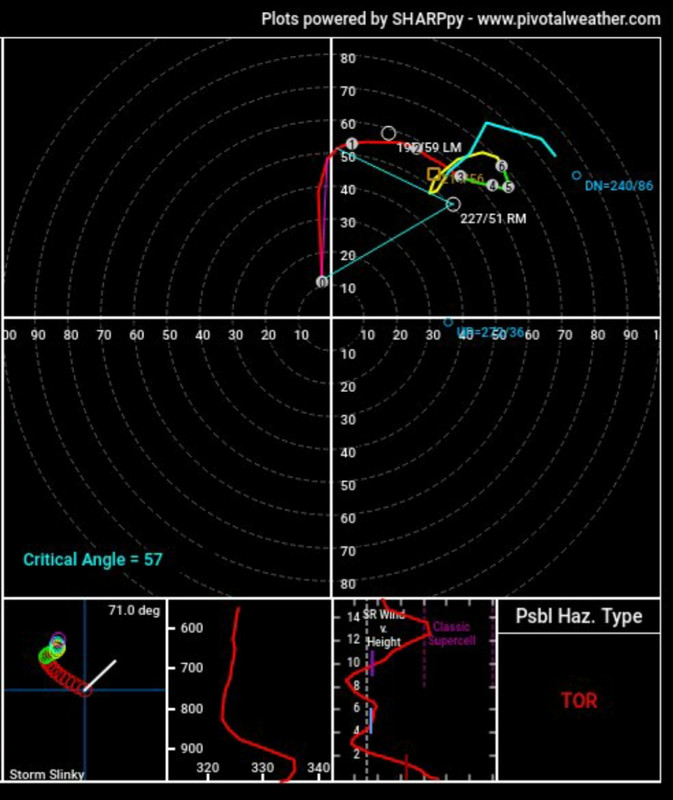
This sounding appears to be from east of Hackleburg, AL.
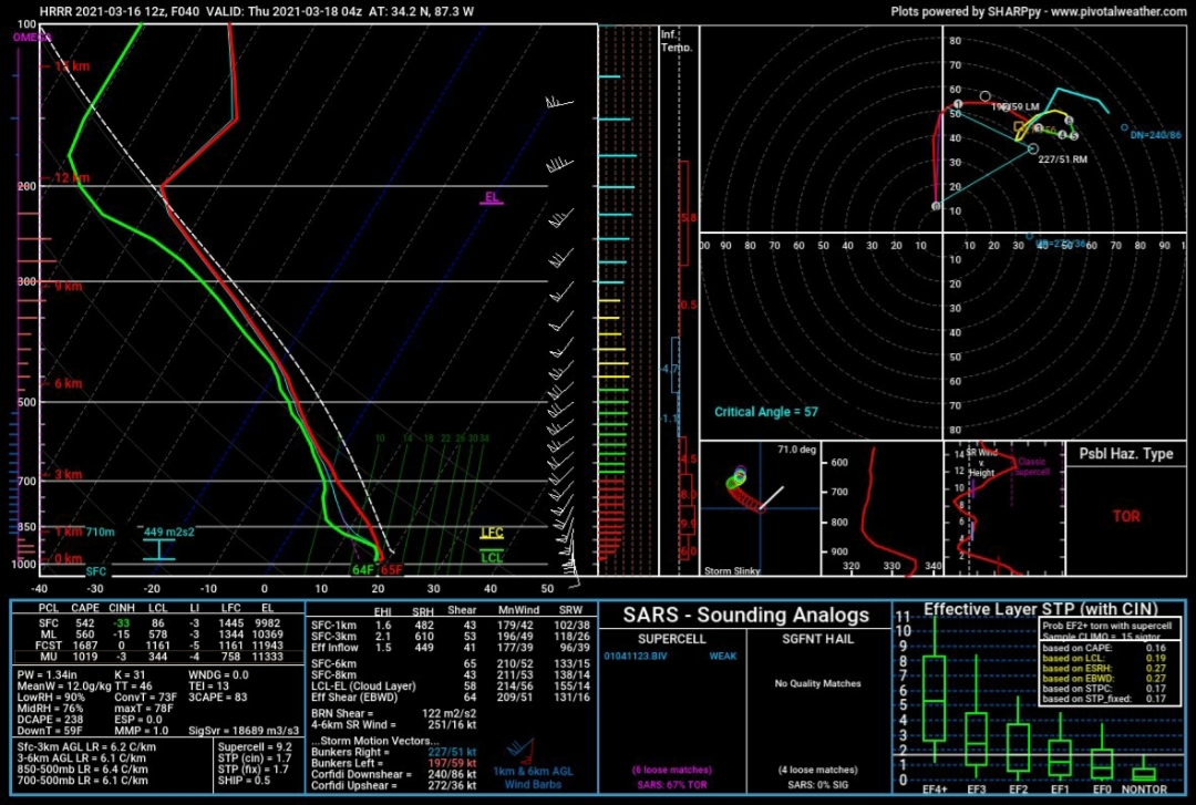
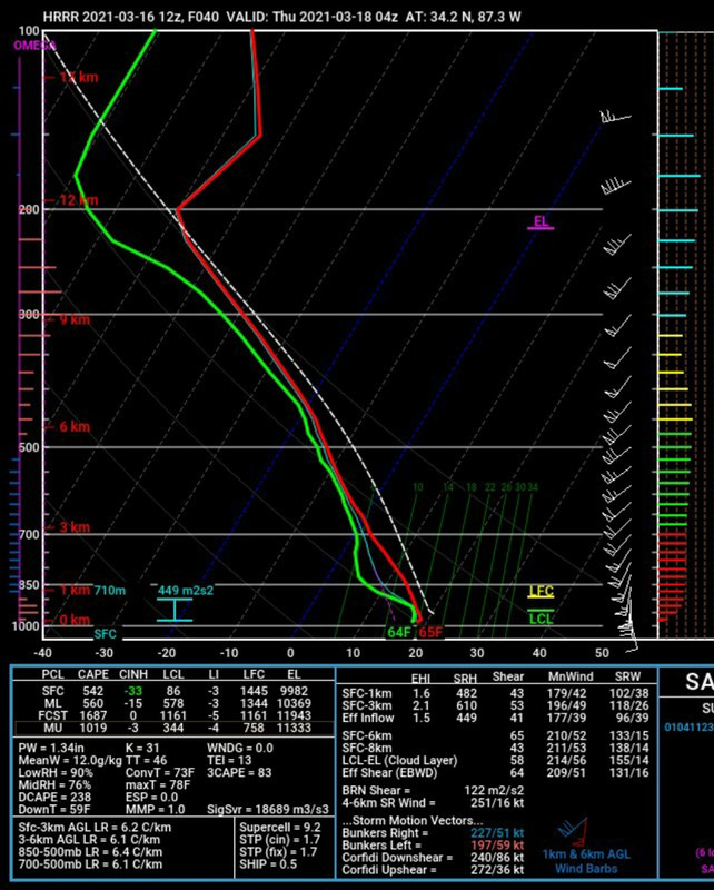
And that hodograph....
And that hodograph....
Posted on 3/16/21 at 2:23 pm to LegendInMyMind
How does one read and interpret the hodograph?
Posted on 3/16/21 at 2:26 pm to CypressTrout10
Posted on 3/16/21 at 2:27 pm to CypressTrout10
quote:
How does one read and interpret the hodograph?
You need to wrangle Duke or rds for the particulars, but the squigglier the wind profile the worse it is.
It indicates shear and change of wind direction at different heights of the atmosphere. Note the "Pos. Hazard Type: TOR" in the bottom right corner. That means if that sounding verified, that cell/part of the storm would have a tornado with it.
The Skew-T is the place to start studying. It is an easier concept that the Hodo.
This post was edited on 3/16/21 at 2:30 pm
Posted on 3/16/21 at 2:27 pm to LegendInMyMind
quote:
2020 gave everyone a break. Suprising, considering everything else about the year was shite.
April 12–13, 2020
Throughout the two-day outbreak, a total of 140 tornadoes touched down across 10 states, inflicting widespread and locally catastrophic damage. The strongest tornado was rated high-end EF4 and occurred in Southern Mississippi, producing estimated winds of 190 mph (310 km/h), reaching a width of 2.25 mi (3.62 km), and causing eight deaths. With a total of 32 tornado-related fatalities, it was the deadliest tornado outbreak since April 27–30, 2014.
Posted on 3/16/21 at 2:28 pm to weadjust
quote:
April 12–13, 2020
Throughout the two-day outbreak, a total of 140 tornadoes touched down across 10 states, inflicting widespread and locally catastrophic damage. The strongest tornado was rated high-end EF4 and occurred in Southern Mississippi, producing estimated winds of 190 mph (310 km/h), reaching a width of 2.25 mi (3.62 km), and causing eight deaths. With a total of 32 tornado-related fatalities, it was the deadliest tornado outbreak since April 27–30, 2014.
I'm aware. I was talking about overall, concerning the entire season, and specifically "High Risk" days.

Posted on 3/16/21 at 2:30 pm to LegendInMyMind
quote:
2020 gave everyone a break. Suprising, considering everything else about the year was shite.
I had a tornado come through half a mile from where I am now on Easter then I went back to Baton Rouge over the summer and had a tornado pass by 200 yards from us early in the morning.
Posted on 3/16/21 at 2:32 pm to LegendInMyMind
quote:
Note the "Pos. Hazard Type: TOR" in the bottom right corner. That means if that sounding verified, that cell/part of the storm would have a tornado with it.
Ignore this box and learn to read it yourself.
Edit: I don't mean to sound mean, I literally mean, learn to read it for yourself rather than relying on that box.
This post was edited on 3/16/21 at 2:49 pm
Posted on 3/16/21 at 2:32 pm to The Boat
quote:
I had a tornado come through half a mile from where I am now on Easter then I went back to Baton Rouge over the summer and had a tornado pass by 200 yards from us early in the morning.
Again, I was referring to no "High Risk" days in 2020.
Posted on 3/16/21 at 2:33 pm to LegendInMyMind
quote:
Again, I was referring to no "High Risk" days in 2020.
Just takes one A-ARON
Posted on 3/16/21 at 2:39 pm to The Boat
quote:
Just takes one A-ARON
True, and I've never said otherwise. But you, or anyone else, cannot deny that 2020 was one of the slowest tornado seasons we've seen in years, nationally, by nearly every metric.
That doesn't change anything about tomorrow's threat, or the tornadoes that did actually touch down last year.
This post was edited on 3/16/21 at 2:40 pm
Posted on 3/16/21 at 2:49 pm to LegendInMyMind
This is from Meteorologist Jim Stefkovich, with the Alabama Emergency Management Agency:
quote:
A dangerous and life-threatening event is unfolding on Wednesday with three rounds of storms. There is a Moderate Risk for much of the state, but don’t get hung up on the specific threat area/color. This will be a statewide event. Having said that, will every person be affected. NO! But, does every inch of the state have the potential for severe weather? YES!
The first two rounds of storms will have limited severe weather coverage. The third is the most certain with widespread and significant severe storms, including strong to violent long-tracked tornadoes.
Round 1 – A few severe storms are possible Wednesday in north Alabama from 7 am – 12 pm north of a Hamilton – Cullman – Centre line. Severe weather, if any, will be limited in coverage.
Round 2 – Models continue to indicate scattered thunderstorm development after 11 am in southwest Alabama, spreading northeast into the northern sections of the state by 6 pm. The atmosphere will be primed for tornadic storms, and any of these thunderstorms could become severe. Wind gusts up to 80 mph (mimicking tornado damage), golf ball hail, and tornadoes are all possible.
Round 3 – A broken line of severe thunderstorms will reach western Alabama between 6-8 pm Wednesday, the I-65 corridor between 11 pm – 2 am and exit the southeast sections of the state between 6 am and 10 am Thursday. This will be the most widespread and dangerous part of the event. Tornadic supercells will likely occur the entire period, including long-tracked EF-2 or stronger tornadoes.
In addition, straight-line winds up to 80 mph and golf ball or larger hail is possible. Thus, the message on Wednesday/Thursday morning is to take NWS Severe Thunderstorm Warnings just as serious as Tornado Warnings.
NOW, is the time to either review or develop your severe weather plan, as additional severe weather events will occur through the spring.
Posted on 3/16/21 at 2:50 pm to weadjust
That massive fricker that went from Bassfield-Soso MS was something else.

Posted on 3/16/21 at 2:55 pm to Roll Tide Ravens
quote:
broken line of severe thunderstorms will reach western Alabama between 6-8 pm Wednesday, the I-65 corridor between 11 pm – 2 am and exit the southeast sections of the state between 6 am and 10 am Thursday
Ahhh, sonofabitch. I'm over on the eastern side and this thing is gonna greet me when I wake up.
Although it does seem like most of the really severe weather gets weakened as it gets to us (maybe has something to do with the bottom portion of the Appalachian mountains breaking that stuff up) but there have been many big tornadoes in my time in a 30 mile radius. This sucks. Hope everyone comes through alright.
Posted on 3/16/21 at 2:55 pm to Roll Tide Ravens
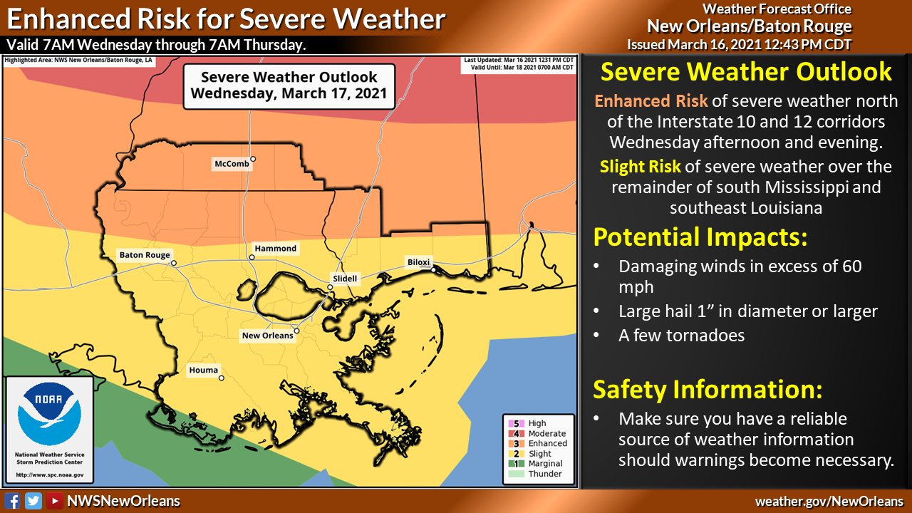
Here are some graphics from the local NWS forecast offices:
NWS Birmingham:

NWS Huntsville:

NWS Jackson:

NWS Memphis:

NWS New Orleans:
NWS Birmingham:
NWS Huntsville:
NWS Jackson:
NWS Memphis:
NWS New Orleans:
This post was edited on 3/16/21 at 3:00 pm

 Page 11 of 64

Popular
Back to top