- My Forums
- Tiger Rant
- LSU Recruiting
- SEC Rant
- Saints Talk
- Pelicans Talk
- More Sports Board
- Coaching Changes
- Fantasy Sports
- Golf Board
- Soccer Board
- O-T Lounge
- Tech Board
- Home/Garden Board
- Outdoor Board
- Health/Fitness Board
- Movie/TV Board
- Book Board
- Music Board
- Political Talk
- Money Talk
- Fark Board
- Gaming Board
- Travel Board
- Food/Drink Board
- Ticket Exchange
- TD Help Board
Customize My Forums- View All Forums
- Show Left Links
- Topic Sort Options
- Trending Topics
- Recent Topics
- Active Topics
Started By
Message


 1
1

Posted on 3/16/21 at 12:59 pm to SM6
My sister in law lives in Bremen. You might be neighbors.

Posted on 3/16/21 at 1:00 pm to Areddishfish
Originally they had slight, moderate, and high. They decided to add marginal and enhanced in 2014.
Posted on 3/16/21 at 1:00 pm to Roll Tide Ravens

Now that’s a spicy meatball

Posted on 3/16/21 at 1:02 pm to deltaland
This is the SPC discussion from the convective outlook.
...Lower MS Valley into AL/GA...
Multiple rounds of intense, severe convection will be possible,
mainly across MS/AL on Wednesday afternoon into the overnight hours.
Convection will intensify along the eastward progressing cold front
across central and eastern AR/LA during the late morning/afternoon
as it encounters effective shear greater than 60 kt, MLCAPE around
1500-2500 J/kg and midlevel lapse rates around 7-8 C/km. Fast storm
motion, with 925-700 mb flow greater than 40 kt will support
widespread damaging gusts with some gusts greater than 65 kt
expected. Large hail (some greater than 2 inch in diameter,
especially from the AR/MO border into northern LA, southwest TN and
northern/central MS) is also expected with this activity.
Further east across northeast LA into MS and AL a more concerning
scenario appears possible. Most forecast guidance agrees that a
round of afternoon thunderstorms are expected. This activity is
expected to develop in weaker ascent, driven by heating and low
level warm advection. Strong 0-3 km shear near 30-40 kt will already
be in place with enlarged low level hodographs evident. Given weaker
forcing, this activity will have an opportunity to remain more
discrete and any cell will quickly become a supercell capable of
producing strong tornadoes. As a 40-50 kt low level jet increases
around 00-03z, intense supercells are expected to advance eastward
along with the cold front across MS and into AL overnight. This will
bring a second round of significant severe storms capable of intense
tornadoes, large hail and intense damaging winds across much of
MS/AL. If these trends are maintained, an upgrade to a High risk
could be necessary with the initial Day 1 Convective Outlook at 06z
tonight.
This post was edited on 3/16/21 at 1:05 pm
Posted on 3/16/21 at 1:02 pm to rds dc
quote:
If these trends are maintained, an upgrade to a High risk
could be necessary with the initial Day 1 Convective Outlook at 06z
tonight.
Yep. They used the "H" word and sent alot of folks into a tizzy.

Posted on 3/16/21 at 1:06 pm to Duckhammer_77
quote:If you’re starting in Baton Rouge I think you’d be fine doing the drive.
Awesome. The one day I have to drive BR to morgan city then lafayette for work.
This post was edited on 3/16/21 at 1:56 pm
Posted on 3/16/21 at 1:07 pm to Roll Tide Ravens
This is starting to set up really bad. I’m getting a sinking feeling about this one
Posted on 3/16/21 at 1:09 pm to LegendInMyMind
You North AL folks, the NWS Huntsville just Tweeted this:
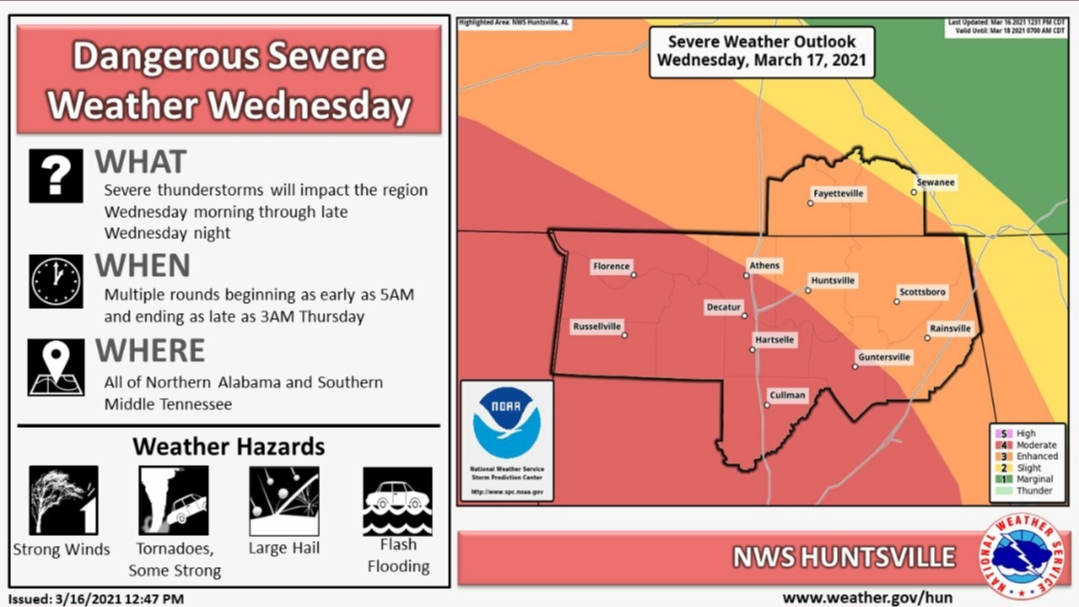
quote:
[1 PM] Confidence continues to increase that a long duration, widespread severe weather event is likely tomorrow across the area, with damaging winds, large hail, and tornadoes. A few tornadoes could be strong and long-tracked. Please stay tuned and make preparations now. #HUNwx LINK
Posted on 3/16/21 at 1:13 pm to LegendInMyMind
quote:
quote:
If these trends are maintained, an upgrade to a High risk
could be necessary with the initial Day 1 Convective Outlook at 06z
tonight.
Yep. They used the "H" word and sent alot of folks into a tizzy.
Based on 12z guidance, if I was going to draw a high it would be centered on a line from Monroe to Tupelo.
Also, chasing? - fast moving nocturnal tornadoes in a messy storm mode. Good luck with all that.
This post was edited on 3/16/21 at 1:20 pm
Posted on 3/16/21 at 1:15 pm to LegendInMyMind
quote:
Yep. They used the "H" word and sent alot of folks into a tizzy.
Considering there's what? One "high" forecast a year?
Posted on 3/16/21 at 1:17 pm to rds dc
quote:
Based on 12z guidance, if I was going to draw a high it would be centered on a line from Monroe to Tupelo.
quote:
rds dc
Been nice knowing you baws
Posted on 3/16/21 at 1:17 pm to East Coast Band
quote:
Considering there's what? One "high" forecast a year?
I'm not saying there shouldn't be a tizzy, just that the mere mention of it stirred it up.
This post was edited on 3/16/21 at 1:18 pm
Posted on 3/16/21 at 1:18 pm to East Coast Band
quote:
Considering there's what? One "high" forecast a year?
Maybe one every 2-3 years at least in this area
Posted on 3/16/21 at 1:21 pm to deltaland
quote:
Maybe one every 2-3 years at least in this area
A couple weeks ago a met on Twitter asked how many "High Risk" areas have you been in? I started thinking that I have spent the majority of my life in North/Central Alabama, and went back to try to see how many it would be. All I could come up with is more than a few.
Posted on 3/16/21 at 1:21 pm to Roll Tide Ravens
Memphis is going to get some heavy storms today.
Posted on 3/16/21 at 1:25 pm to East Coast Band
quote:
Considering there's what? One "high" forecast a year?
2011 had 5 (4 of those were part of 2 day outbreaks though) 2014 had 3, 2017 had 4, 2019 had 1. And here we are.
This post was edited on 3/16/21 at 1:26 pm
Posted on 3/16/21 at 1:25 pm to Roll Tide Ravens
Wasn’t too nervous about the weather, and don’t generally get nervous about severe weather, but I’m starting to get nervous now for up here in Monroe, since they updated the threat to moderate. Got an uneasy feeling about tomorrow. Stay safe baws
Posted on 3/16/21 at 1:29 pm to GEAUXmedic
quote:
2011 had 5 (4 of those were part of 2 day outbreaks though) 2014 had 3, 2017 had 4, 2019 had 1. And here we are.
2020 gave everyone a break with High Risk days. Suprising, considering everything else about the year was shite.
This post was edited on 3/16/21 at 10:46 pm
Posted on 3/16/21 at 1:56 pm to deltaland


 Page 10 of 64

Popular
Back to top