- My Forums
- Tiger Rant
- LSU Recruiting
- SEC Rant
- Saints Talk
- Pelicans Talk
- More Sports Board
- Fantasy Sports
- Golf Board
- Soccer Board
- O-T Lounge
- Tech Board
- Home/Garden Board
- Outdoor Board
- Health/Fitness Board
- Movie/TV Board
- Book Board
- Music Board
- Political Talk
- Money Talk
- Fark Board
- Gaming Board
- Travel Board
- Food/Drink Board
- Ticket Exchange
- TD Help Board
Customize My Forums- View All Forums
- Show Left Links
- Topic Sort Options
- Trending Topics
- Recent Topics
- Active Topics
Started By
Message
re: TS Jerry, TS Karen & More Areas to Watch - Peak Season
Posted on 9/6/19 at 12:19 pm to LSURussian
Posted on 9/6/19 at 12:19 pm to LSURussian
Meh, there are plenty of storms that form in the eastern Pacific we only kind of believe will be Katrina on steroids.
 0
0


Posted on 9/6/19 at 12:22 pm to LSURussian
quote:
According to this board every tropical system that forms in the western hemisphere is the next Katrina.
Or Betsy, or Andrew or pick any bad storm.
Posted on 9/6/19 at 12:23 pm to Duke
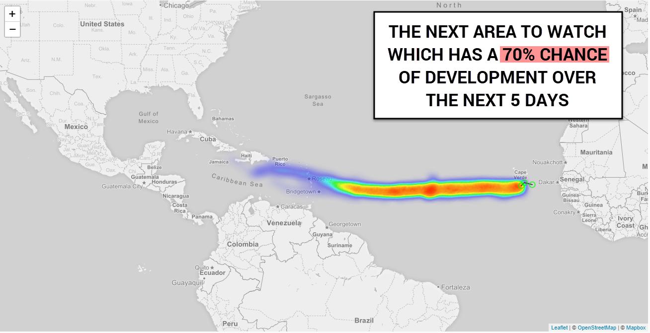
Duke...94L about 7-8 days from lesser Antilles ? Another 5 days if it b-lined it into Gulf ? That would be around September 17-19 th. Digging troughs would recurve it by that late time ???
Or is a possible strong upper level ridge possibly build over southeast US ? What do you think might occur ?
Or is a possible strong upper level ridge possibly build over southeast US ? What do you think might occur ?
This post was edited on 9/6/19 at 12:25 pm
Posted on 9/6/19 at 12:34 pm to Klingler7
He can't give you his opinion on something that far off. Nobody can. Well, I suppose he can but why? Kinda pointless to bring scenarios up when the full picture possibilities aren't even available yet. I wouldn't worry about it right now.
GFS has this thing hitting Florida in fantasy land time taking a classic Cape Verde storm path. Yesterday I believe it had it a stronger storm curving east of Florida out to sea.
Dorian seemed like it decided to hang around for 3 weeks before it skirted up the east coast. Yeah, hyperbole but sure as hell felt like it.
This post was edited on 9/6/19 at 12:42 pm
Posted on 9/6/19 at 12:38 pm to LSURussian
quote:
According to this board every tropical system that forms in the western hemisphere is the next Katrina.
You kinda missed the satirical point of my post
Posted on 9/6/19 at 12:41 pm to Klingler7
quote:
Or is a possible strong upper level ridge possibly build over southeast US ? What do you think might occur ?
Predicting that far out is a fool's errand.
You know how this goes, guessing at where the subtropical ridge in the Atlantic is set up first. All the globals too far out to really trust much of anything. Would need to get it close to worry past that. Euro has a hell of an opening about the time our future storm would be running toward the Antilles. Big ridge over western europe, another one stacked right over the SE US. Door wide open in between. It builds in over the entire basin soon after though, like the GFS shows.
Assuming it gets tucked under and runs the route either in the Caribbean or north of the Antilles, then it's just pure guesswork.
Euro at 240 would have an obvious curve north in the gulf. Wants zonal flow across the north and west of the US. GFS digs a stout trough into the rockies and builds out an upper ridge in the SW Atlatnic.
Way too much error at that point though to be any better than a dartboard. The trend in recent years has seemed to be bringing troughs digging deep enough to get to the gulf a little later, so probably bet on the typical summer SE ridge being there all else being equal.

Posted on 9/6/19 at 12:44 pm to rds dc
No way this becomes a hurricane
Posted on 9/6/19 at 12:45 pm to Duke
Looks like we might have an extended summer pattern for hurricane season this year?
Posted on 9/6/19 at 12:54 pm to LSURussian
quote:
According to this board every tropical system that forms in the western hemisphere is the next Katrina.
The people opinion that matter don't do this and neither do 95% of the other posters.
Not sure why this narrative gets tossed around every time a tropical thread gets started.
Posted on 9/6/19 at 1:05 pm to deuce985
quote:
Kinda pointless to bring scenarios up when the full picture possibilities aren't even available yet.
I think he is a met of some sort, so I think he knows it's just guessing to say anything for sure.
Right now, it's more just getting an idea of the early steps of the steering. Looking at the Euro as a guide, the leftovers of Dorian merge with a trough and slide toward Europe. The other TS out the eastern Atlantic gets pulled up toward Europe too. You can kind of imagine a wave breaking as all this approaches Europe, breaking toward the SW generally off western Europe.
Which, assuming I actually have some understanding of what's happening and not knowing just enough to be a dangerous fool, would send some anticylconic vorticity toward the middle of the Atlantic. This would lead to heights rising (ridge getting bigger), and would probably build west over time.
Obviously, I'm not anywhere near being an expert on shite like this and am simplifying the process. So take with a grain of salt. Assuming that the heights build out like is, which is at least shown in both the GFS and Euro, it's will be a question of where 94L is (can it get out to sea before getting stuck under the easterly flow pushing west), the exact orientation of the building high, and if the system bothers to develop.
Not worried about anything else until this first piece is resolved.
This post was edited on 9/6/19 at 1:06 pm
Posted on 9/6/19 at 1:09 pm to rbWarEagle
No More Hurricanes near Florida Dammit!! On a good note gas is ready and generators are full 

Posted on 9/6/19 at 1:16 pm to Duke
really unfortunately in this thread...I have a cruise leaving NOLA on the 22nd because yes....I'm that damn trashy... this thread has officially given me tFear
Posted on 9/6/19 at 1:18 pm to scott8811
quote:
this thread has officially given me tFear
No need for tFear for like another 10 days.
Posted on 9/6/19 at 1:19 pm to FLObserver
Better stabilize that fuel baw
Posted on 9/6/19 at 1:20 pm to Duke
I need this 7 days of non-stop maritime booze more than I can describe...I will have tFear beginning now lol
Posted on 9/6/19 at 1:26 pm to scott8811
rds made this thread so that means without him saying it time to pucker asses
I'm kidding but it has a possibility of being a threat to US.
I'm kidding but it has a possibility of being a threat to US.
Posted on 9/6/19 at 1:58 pm to WestCoastAg
quote:
let me know when i need to make my first rush to the HEB to stock up on bread
You needed to do that this morning. Too late now. Sorry.
Posted on 9/6/19 at 3:07 pm to Quidam65
Imma wait for peej to chime in before I wig out over this one.
Posted on 9/6/19 at 3:42 pm to roadGator

Posted on 9/6/19 at 3:42 pm to GEAUXmedic
dont like that one bit

 Page 4 of 30

Popular
Back to top