- My Forums
- Tiger Rant
- LSU Recruiting
- SEC Rant
- Saints Talk
- Pelicans Talk
- More Sports Board
- Fantasy Sports
- Golf Board
- Soccer Board
- O-T Lounge
- Tech Board
- Home/Garden Board
- Outdoor Board
- Health/Fitness Board
- Movie/TV Board
- Book Board
- Music Board
- Political Talk
- Money Talk
- Fark Board
- Gaming Board
- Travel Board
- Food/Drink Board
- Ticket Exchange
- TD Help Board
Customize My Forums- View All Forums
- Show Left Links
- Topic Sort Options
- Trending Topics
- Recent Topics
- Active Topics
Started By
Message
re: TS Jerry, TS Karen & More Areas to Watch - Peak Season
Posted on 9/19/19 at 11:42 am to redstick13
Posted on 9/19/19 at 11:42 am to redstick13
quote:
I think I will be stuck here in uptown tonight. It’s flooded between here and my house and the forecast has it continuing until 7PM. I have a coworker in Conroe and he was barely able to make it home in his F250.
Wouldn't drive around Houston right now, especially if going east.
The overall thinking is the rainfall rates should lessen into the later afternoon for a number of technical reasons. That being said, that band set up across the southern part of Houston is stout. Definitely small drops but giving back heavy radar returns, means it's dropping at a rapid rate.
 1
1

Posted on 9/19/19 at 11:44 am to Duke
man, some of the pictures and videos coming in on Twitter are unreal...

Posted on 9/19/19 at 11:45 am to tgrbaitn08
(no message)
This post was edited on 4/10/23 at 3:48 pm
Posted on 9/19/19 at 11:47 am to msutiger
Posted on 9/19/19 at 11:47 am to Duke
quote:
SW side of the outer loop under the heaviest rain currently.
Surprised seen very little rain here all morning from my office on the SW side. Must be looking out the wrong window
Posted on 9/19/19 at 11:55 am to HYDRebs

Posted on 9/19/19 at 12:33 pm to tgrbaitn08
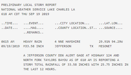
25 inches in 12 hrs? Damn

Posted on 9/19/19 at 12:37 pm to BallsEleven
Not a great photo, but a buddy in Houston sent me this.
That’s pretty damn high up that stop sign.

That’s pretty damn high up that stop sign.

Posted on 9/19/19 at 2:41 pm to McCaigBro69
Per a meteorologist I follow on Facebook
quote:
Sometimes, a mesoscale flooding rain event can be used to predict future excessive precipitation threats. Consider that some communities between Houston and Beaumont in Texas may have received upwards of 40 inches of rain from the remnant of Tropical Storm Imelda (with more coming, until the circulation lifts up into the Arklatex on Friday). How could such a small disturbance produce so much water?
Satellite views show two causes. One is the slow motion of the system (that is how Allison achieved a similar feat in 2001). The other issue was noted in torrential rainfall cases in the summer of 2007, and of course Hurricane Harvey in 2017. That is, the "triple play moisture fetch". Satellite imagery shows a high dewpoint flow from three sources: the equatorial Pacific Ocean, western Gulf of Mexico/Bay Of Campeche, and the Caribbean Sea. That much convergence into a dwarf circulation produced repeated thunderstorm formation, and training echo patterns about the little low pressure center. Think of the disruption to utilities and transportation along the Interstate 10 corridor. Could it happen again?
Well after maybe two weeks of a stable heat ridge (high cooling demand in some areas without power), numerical models show a tropical feature in the Yucatan Strait on October 4th.

Posted on 9/19/19 at 2:42 pm to McCaigBro69

Posted on 9/19/19 at 2:45 pm to Prominentwon


Posted on 9/19/19 at 2:48 pm to Prominentwon
quote:
numerical models show a tropical feature in the Yucatan Strait on October 4th.
2 weeks away? Gtfo

Posted on 9/19/19 at 2:57 pm to Rize
Sheppard @ Westheimer around 2 this afternoon:

Posted on 9/19/19 at 2:58 pm to Cosmo
shite got a wedding down in Mexico that weekend
And this flooding is crazy, gotta feel for those people dealing with this 3 years later.
And this flooding is crazy, gotta feel for those people dealing with this 3 years later.
Posted on 9/22/19 at 3:59 am to rds dc
Starting to see some signs that the Gulf might open up.


Posted on 9/22/19 at 4:35 am to rds dc
Hhhmmm,mmm
Posted on 9/22/19 at 5:10 am to rds dc
Track density view, it appears that the majority of the westward tracks might be Karen?


Day 10 Euro bends this all the way back to the Gulf

Day 10 Euro bends this all the way back to the Gulf
This post was edited on 9/22/19 at 5:14 am

Posted on 9/22/19 at 6:05 am to rds dc
I want cooler weather.
I've had enough of 90+degrees everyday of september.
I've had enough of 90+degrees everyday of september.
Posted on 9/22/19 at 6:06 am to rds dc
We have seen this before this season in the long range ensembles but haven't seen a system actually get turned westward. The Day 10 Euro EPS would suggest a westward track for Karen, if it verifies.

Posted on 9/22/19 at 6:14 am to pioneerbasketball
quote:
I've had enough of 90+degrees everyday of september.
The GFS does have it pretty fall like for the Utah State game with a nice cool 88F

 Page 29 of 30

Popular
Back to top