- My Forums
- Tiger Rant
- LSU Recruiting
- SEC Rant
- Saints Talk
- Pelicans Talk
- More Sports Board
- Coaching Changes
- Fantasy Sports
- Golf Board
- Soccer Board
- O-T Lounge
- Tech Board
- Home/Garden Board
- Outdoor Board
- Health/Fitness Board
- Movie/TV Board
- Book Board
- Music Board
- Political Talk
- Money Talk
- Fark Board
- Gaming Board
- Travel Board
- Food/Drink Board
- Ticket Exchange
- TD Help Board
Customize My Forums- View All Forums
- Show Left Links
- Topic Sort Options
- Trending Topics
- Recent Topics
- Active Topics
Started By
Message
 1
1


Posted on 8/27/19 at 4:44 pm to ScaryClown
I'm copying this from another forum, but it explains it well.
quote:
Just to reiterate. This model cycle all need to be technically thrown out due to the initialization. A more right system early on equals a more left system later on.
But think of it this way. with the track that is steady nw to wnw dorian from its earlier position would keep it moving along the edge of the building ridge over the Atlantic ...before the secondary building ridge behind TD6 builds in and thus would gain more latitude over all.
In the case that dorian is right of the track, as it is right now, means that it will be deeper behind the already entrenched Bermuda high and will turn west at a lower latitude and farther east which would allow the ridge to build west and close any gap up when the ridge behind TD6 fills in.
hence why you see in the models everything that was on the right side of the envelope ended up stronger and farther south overall.
Posted on 8/27/19 at 4:45 pm to ScaryClown
Because the models are showing it skipping across Florida into the Gulf
Posted on 8/27/19 at 4:46 pm to notiger1997
A hurricane tracking west just north of Miami is never a good thing for Louisiana. Hopefully it hits further up the coast but I definitely don’t like the way the track is trending
Posted on 8/27/19 at 4:47 pm to Zephyrius
quote:
Was it Juan in 1985 or '86 which stalled off the coast south of Mobile then suddenly took off east through Lake Borgne and the Lake. Then eventually passing through Baton Rouge.
It was Hurricane Juan and I was stuck in Venetian Isles for 5 days before we could get out because the water was so high. It was 6 to 8 feet above normal flood stage. The only land you could see was the L&N train bridge.
Posted on 8/27/19 at 4:52 pm to thesoccerfanjax
This post was edited on 8/27/19 at 4:53 pm
Posted on 8/27/19 at 4:53 pm to MrLSU
18z ICON:

Posted on 8/27/19 at 4:54 pm to MrLSU
Even that one looks like it has one going straight up the pooper of new orleans
Posted on 8/27/19 at 4:55 pm to MrLSU
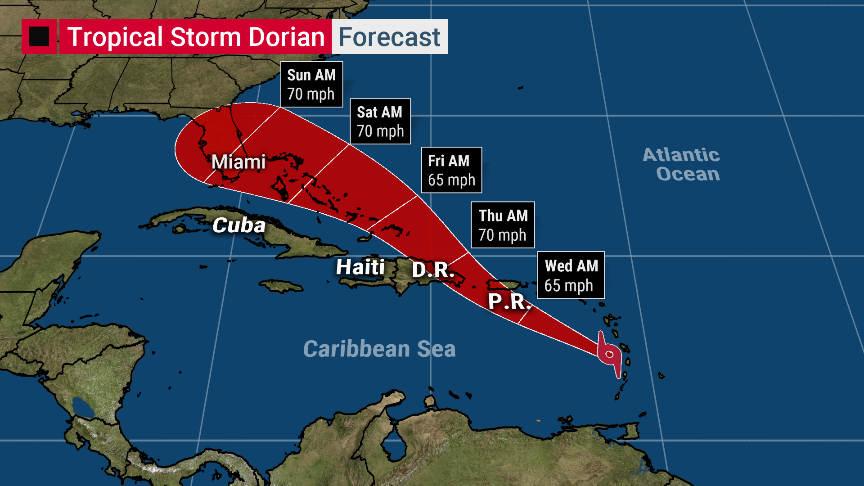
Somebody screenshot that cone so we can compare to a few days from now.
Posted on 8/27/19 at 5:00 pm to OysterPoBoy
18z GFS coming in a LOT stronger, and still east.
Posted on 8/27/19 at 5:06 pm to GEAUXmedic
quote:
18z GFS coming in a LOT stronger, and still east.
Looks like N. FL or Georgia, which should safely keep it out of the Gulf.
Posted on 8/27/19 at 5:06 pm to GEAUXmedic
Looks like it has it near the Georgia/Florida border this time on landfall.
962mb damn
962mb damn
This post was edited on 8/27/19 at 5:07 pm
Posted on 8/27/19 at 5:11 pm to TDsngumbo
quote:
Has a hurricane ever come into NOLA from due east? I remember thinking Erin was going to do that back in 1995 or 1996 but it ended up curving northward into the panhandle.
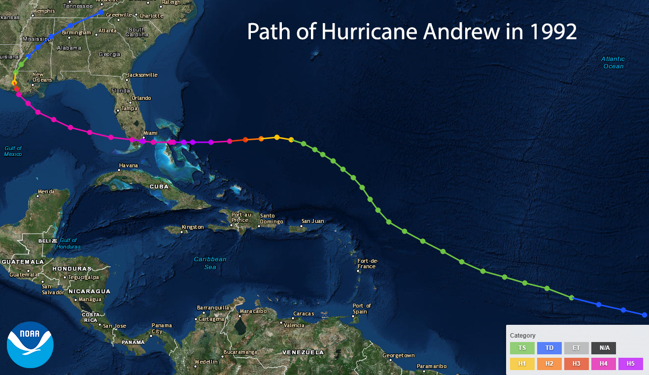
Pretty close
Posted on 8/27/19 at 5:14 pm to GEAUXmedic
That explanation actually reinforces one of the earlier models that had a further south stronger ridge. Icon I think it was
Posted on 8/27/19 at 5:14 pm to rds dc
So basically we need to see how far north and east it gets before it makes its bend back to the west to see if it eventually would get into the Gulf?
Posted on 8/27/19 at 5:14 pm to rds dc
what's interesting on this GFS run is not only is it much further north, it stays on a general nw path so far it's showing before landfall before it makes that possible west movement. It then seems to slow down and doesn't move a lot for 36 hours. It just lingers near FL/GA border before sliding into GA. That's a big change from their last run.
This post was edited on 8/27/19 at 5:16 pm
Posted on 8/27/19 at 5:15 pm to GEAUXmedic
Oh frick that track
Posted on 8/27/19 at 5:16 pm to deltaland
Would be worst case scenario for gulf especially if it missed any land interactions as it made that path
Posted on 8/27/19 at 5:16 pm to deltaland
Katrina-level timing, IMO
Posted on 8/27/19 at 5:18 pm to GEAUXmedic
It will probably just swing to the north after it crosses Florida. Example below:


 Page 16 of 263

Popular
Back to top