- My Forums
- Tiger Rant
- LSU Recruiting
- SEC Rant
- Saints Talk
- Pelicans Talk
- More Sports Board
- Fantasy Sports
- Golf Board
- Soccer Board
- O-T Lounge
- Tech Board
- Home/Garden Board
- Outdoor Board
- Health/Fitness Board
- Movie/TV Board
- Book Board
- Music Board
- Political Talk
- Money Talk
- Fark Board
- Gaming Board
- Travel Board
- Food/Drink Board
- Ticket Exchange
- TD Help Board
Customize My Forums- View All Forums
- Show Left Links
- Topic Sort Options
- Trending Topics
- Recent Topics
- Active Topics
Started By
Message
re: May 4th Severe Weather Threat Thread (Flash Flood Emergency - Birmingham & Hoover, Ala.)
Posted on 5/4/21 at 9:37 am to rt3
Posted on 5/4/21 at 9:37 am to rt3
Lot of discreet cells popping up across MS. It’s 80 degrees and humid as hell.
Tornado potential was supposed to be hampered by cluttered convection but it looks like it may overperform
Tornado potential was supposed to be hampered by cluttered convection but it looks like it may overperform
 1
1

Posted on 5/4/21 at 10:24 am to deltaland
They may have been discreet for a bit, but the map is filling in now. I think every snail and earthworm within 200 yards of my house has made a mad dash for my porch. It absolutely dumped rain earlier, and it lasted a while.
Posted on 5/4/21 at 10:27 am to LegendInMyMind
You can see the line we will be dealing with this afternoon/evening blowing up near Shreveport now.
Posted on 5/4/21 at 10:54 am to LegendInMyMind
Posted on 5/4/21 at 11:04 am to LegendInMyMind
Yea that cluster is a mess in NW La

Posted on 5/4/21 at 11:19 am to deltaland
Posted on 5/4/21 at 11:22 am to deltaland
I feel like I’m gonna mostly miss the dreaded second line but we shall see how it all shakes out
Posted on 5/4/21 at 11:24 am to Bobby OG Johnson
A decent couplet with that storm right now.
And as soon as I said that, it kind of broadened.
And as soon as I said that, it kind of broadened.
This post was edited on 5/4/21 at 11:25 am
Posted on 5/4/21 at 11:26 am to LegendInMyMind
quote:
Meteorologist Nick Mikulas
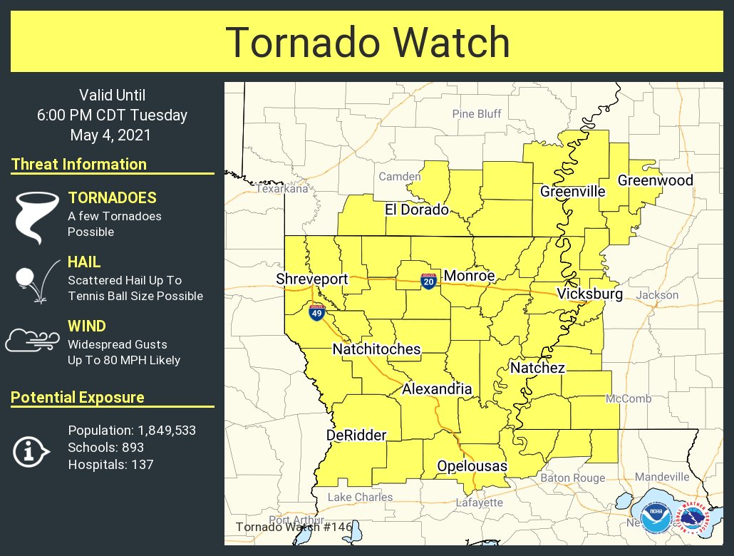
A tornado watch has been issued for most of the area until 6:00 PM. Isolated tornadoes, large hail, and damaging wind are possible through the afternoon. Things are about to ramp up.
Posted on 5/4/21 at 11:31 am to rt3
Pretty good wind in that part of the line East of Shreveport now. Probably what led to the ST Warning.
Posted on 5/4/21 at 11:41 am to LegendInMyMind
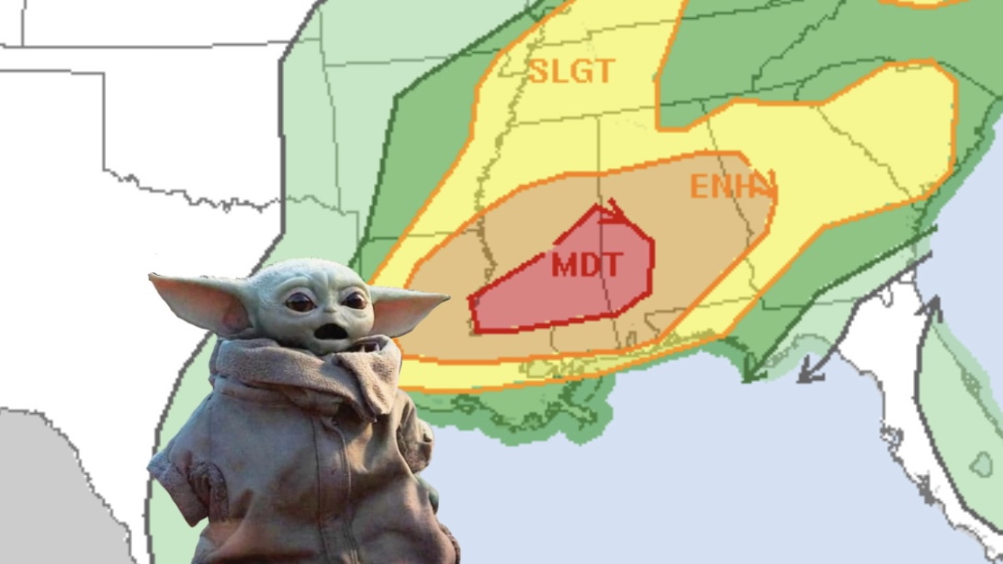
Upgrade to Moderate Risk:
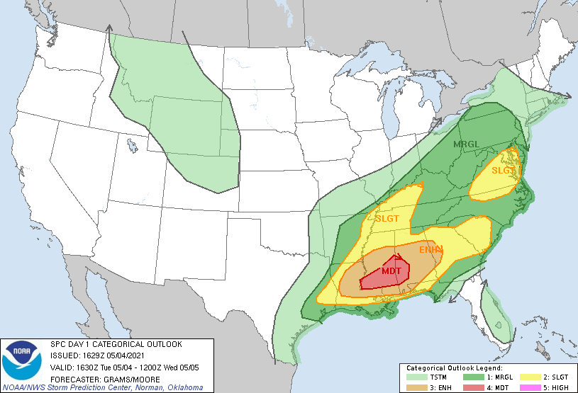
Primary severe threat is high wind and hail:

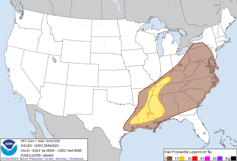
5% prob. outlook for tornadoes.
Primary severe threat is high wind and hail:
5% prob. outlook for tornadoes.
This post was edited on 5/4/21 at 11:44 am

Posted on 5/4/21 at 11:41 am to LegendInMyMind
Getting a little spicier along I-20 than hrrr thought
Posted on 5/4/21 at 11:42 am to The Boat
Cell heading through Monroe is starting to get some rotation
Posted on 5/4/21 at 11:43 am to The Boat
Nice thunderstorms starting to pop up. It’s about to come down in West Monroe
Posted on 5/4/21 at 11:45 am to LegendInMyMind
quote:
@stormchasernick
Posted on 5/4/21 at 11:49 am to LegendInMyMind
Those cells around Monroe ahead of the storm clusters concern me. They’re headed right to my area and it’s prime here for development. 86 and humid sun is out and it wasn’t supposed to be this warm or sunny today
Posted on 5/4/21 at 11:52 am to deltaland
I wonder if that current storm in Monroe will turn into something tornadic. Already starting to kind of see rotation in the super res velo radar. Not necessarily rotation but green and red mixing into gray
This post was edited on 5/4/21 at 11:54 am
Posted on 5/4/21 at 11:52 am to sta4ever
If you put the radar in motion these cells are really gaining strength rapidly
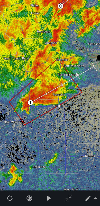
Posted on 5/4/21 at 11:53 am to deltaland
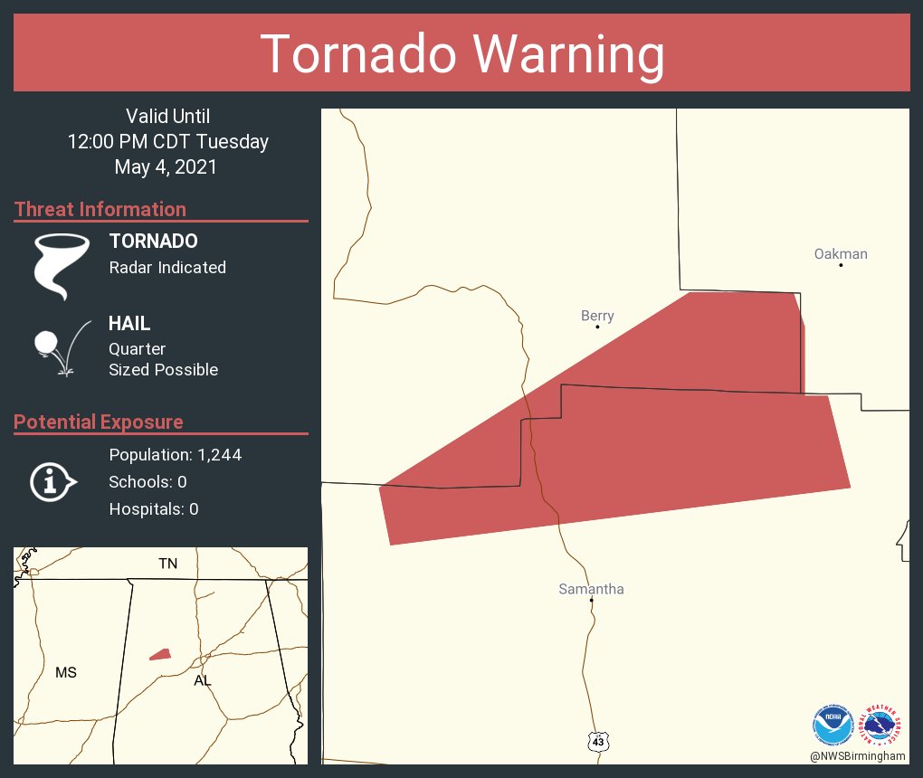
Tail end storm West of DeRidder is trying to rotate.
And it is now warned.
And it is now warned.
This post was edited on 5/4/21 at 11:54 am

 Page 18 of 28

Popular
Back to top