- My Forums
- Tiger Rant
- LSU Recruiting
- SEC Rant
- Saints Talk
- Pelicans Talk
- More Sports Board
- Fantasy Sports
- Golf Board
- Soccer Board
- O-T Lounge
- Tech Board
- Home/Garden Board
- Outdoor Board
- Health/Fitness Board
- Movie/TV Board
- Book Board
- Music Board
- Political Talk
- Money Talk
- Fark Board
- Gaming Board
- Travel Board
- Food/Drink Board
- Ticket Exchange
- TD Help Board
Customize My Forums- View All Forums
- Show Left Links
- Topic Sort Options
- Trending Topics
- Recent Topics
- Active Topics
Started By
Message
re: Severe Weather Rolls On: May 7-10, 2024
Posted on 5/8/24 at 8:40 pm to LegendInMyMind

Posted on 5/8/24 at 8:40 pm to LegendInMyMind
Everything's quiet. Even these a-hole cicadas have took it down a few notches.
Not a breeze to be found.
Not a breeze to be found.
 0
0


Posted on 5/8/24 at 8:41 pm to Roll Tide Ravens
Heck of an event going on this evening.

Posted on 5/8/24 at 8:41 pm to calcotron
Ignore what looks like a big CC drop.
This post was edited on 5/8/24 at 8:43 pm

Posted on 5/8/24 at 8:42 pm to Bobby OG Johnson
quote:
NWS Huntsville
@NWSHuntsville
8:37pm SEEK SHELTER NOW if you are in the path of this storm, tornado has been observed on the ground! Tornado is west of Athens moving NW.
#HUNwx
Posted on 5/8/24 at 8:46 pm to LegendInMyMind
The Athens, AL storm looks broader now.
Posted on 5/8/24 at 8:48 pm to LegendInMyMind
The circulation south of Ardmore seems to be ramping up.
Posted on 5/8/24 at 8:49 pm to Roll Tide Ravens
Postimg isn't cooperating now.
Posted on 5/8/24 at 8:49 pm to LegendInMyMind
quote:
You're doing good work. I haven't been posting any screen grabs for watching the tv.
Thanks buddy. I really enjoy having guys like you and Bobby to talk weather with during these events.
Posted on 5/8/24 at 8:49 pm to Roll Tide Ravens
quote:
The circulation south of Ardmore seems to be ramping up.
It just went warned again.
Posted on 5/8/24 at 8:50 pm to LegendInMyMind
Brad Travis is point out Buccee’s for us. Looks like it’ll be just north of there.
Posted on 5/8/24 at 8:51 pm to Roll Tide Ravens
Posted on 5/8/24 at 8:52 pm to LegendInMyMind
Severe Weather Statement
National Weather Service Huntsville AL
851 PM CDT Wed May 8 2024
ALC083-089-090230-
/O.CON.KHUN.TO.W.0018.000000T0000Z-240509T0230Z/
Madison AL-Limestone AL-
851 PM CDT Wed May 8 2024
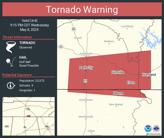
...A TORNADO WARNING REMAINS IN EFFECT UNTIL 930 PM CDT FOR
NORTHWESTERN MADISON AND NORTHEASTERN LIMESTONE COUNTIES...
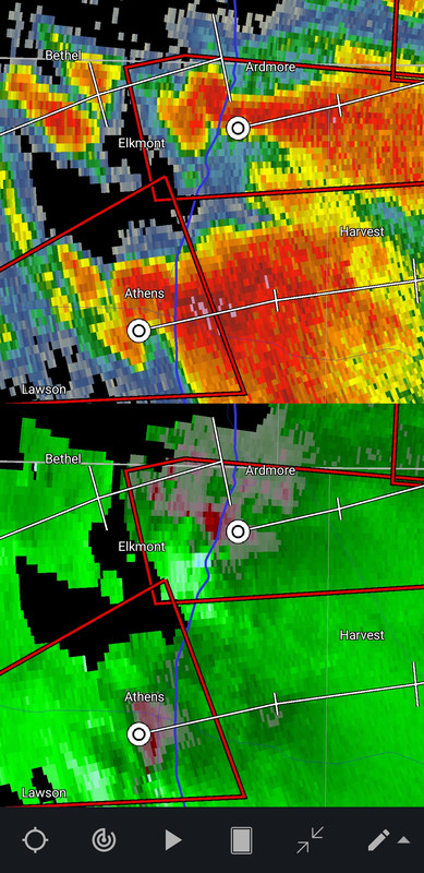
At 851 PM CDT, a confirmed tornado was located near Ardmore, or 10
miles northeast of Athens, moving east at 35 mph.
HAZARD...Damaging tornado and ping pong ball size hail.
SOURCE...Weather spotters confirmed tornado.
IMPACT...Flying debris will be dangerous to those caught without
shelter. Mobile homes will be damaged or destroyed. Damage
to roofs, windows, and vehicles will occur. Tree damage is
likely.
This tornado will be near...
Ardmore around 855 PM CDT.
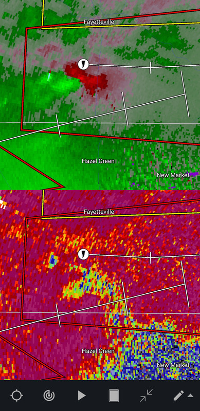
Hazel Green around 915 PM CDT.
Other locations impacted by this tornadic thunderstorm include Fisk,
Toney, Elkwood, Plevna, Holland Gin, and Elkmont.
National Weather Service Huntsville AL
851 PM CDT Wed May 8 2024
ALC083-089-090230-
/O.CON.KHUN.TO.W.0018.000000T0000Z-240509T0230Z/
Madison AL-Limestone AL-
851 PM CDT Wed May 8 2024
...A TORNADO WARNING REMAINS IN EFFECT UNTIL 930 PM CDT FOR
NORTHWESTERN MADISON AND NORTHEASTERN LIMESTONE COUNTIES...
At 851 PM CDT, a confirmed tornado was located near Ardmore, or 10
miles northeast of Athens, moving east at 35 mph.
HAZARD...Damaging tornado and ping pong ball size hail.
SOURCE...Weather spotters confirmed tornado.
IMPACT...Flying debris will be dangerous to those caught without
shelter. Mobile homes will be damaged or destroyed. Damage
to roofs, windows, and vehicles will occur. Tree damage is
likely.
This tornado will be near...
Ardmore around 855 PM CDT.
Hazel Green around 915 PM CDT.
Other locations impacted by this tornadic thunderstorm include Fisk,
Toney, Elkwood, Plevna, Holland Gin, and Elkmont.
Posted on 5/8/24 at 8:53 pm to LegendInMyMind
This storm about halfway between Murfreesboro and Chattanooga looks bad.

Posted on 5/8/24 at 8:54 pm to Roll Tide Ravens
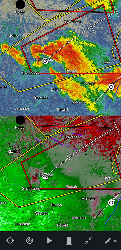
New tornado warning for Jackson and DeKalb Counties in NE Alabama.
Posted on 5/8/24 at 8:54 pm to Roll Tide Ravens
Our Sand Mountain poster needs to watch out.
This post was edited on 5/8/24 at 8:55 pm
Posted on 5/8/24 at 8:55 pm to Roll Tide Ravens
Tornado warning for the Athens storm has been extended into Madison County. Includes most of Huntsville.
Posted on 5/8/24 at 8:57 pm to Roll Tide Ravens
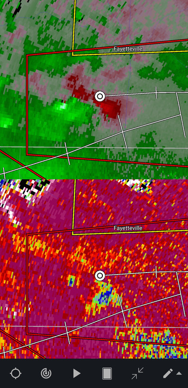
Confirmed tornado south of Fayetteville, TN.

Posted on 5/8/24 at 8:58 pm to Roll Tide Ravens
I don't know how much money we have allocated to the EMA of my county to get area-specific sirens, but it was all a waste. Every warning has sounded the sirens all across the county.

 Page 17 of 36

Popular
Back to top