- My Forums
- Tiger Rant
- LSU Recruiting
- SEC Rant
- Saints Talk
- Pelicans Talk
- More Sports Board
- Fantasy Sports
- Golf Board
- Soccer Board
- O-T Lounge
- Tech Board
- Home/Garden Board
- Outdoor Board
- Health/Fitness Board
- Movie/TV Board
- Book Board
- Music Board
- Political Talk
- Money Talk
- Fark Board
- Gaming Board
- Travel Board
- Food/Drink Board
- Ticket Exchange
- TD Help Board
Customize My Forums- View All Forums
- Show Left Links
- Topic Sort Options
- Trending Topics
- Recent Topics
- Active Topics
Started By
Message
re: Major Hurricane! Joaquin! Finally Moving Northward and OTS
Posted on 9/30/15 at 6:00 pm to Sellecks Moustache
Posted on 9/30/15 at 6:00 pm to Sellecks Moustache
Joaquin about to wreck shite in Baltimore and DC


Posted on 9/30/15 at 6:05 pm to rds dc
How long before it turns into a Super Storm?
Posted on 9/30/15 at 6:07 pm to rds dc
I've gotten a pussy and a cat the last two times a storm's hit the New York City area.
Posted on 9/30/15 at 6:39 pm to Sellecks Moustache
Posted on 9/30/15 at 7:18 pm to cajunangelle
Recon data indicates that Joaquin is bombing out this evening.
Posted on 9/30/15 at 7:22 pm to elprez00
quote:
How long before it turns into a Super Storm?
Posted on 9/30/15 at 8:02 pm to zelman
I did not see this hitting the East coast. Either I wasn't paying attention or models shifted quickly. I suppose they could still shift East but it would probably just mean a hit further up the coast because the pattern seems to strongly suggest an eventual WNW or NW turn.
This post was edited on 9/30/15 at 8:03 pm
Posted on 9/30/15 at 8:08 pm to BigB0882
They are saying this storm is unpredictable, so just keep an eye on this.
The hurr tracker app is good, it has iPad iPhone and online.
They seem to do a good job of keeping things up to date with out the doom and gloom of MSM.
The hurr tracker app is good, it has iPad iPhone and online.
They seem to do a good job of keeping things up to date with out the doom and gloom of MSM.
This post was edited on 9/30/15 at 8:33 pm
Posted on 9/30/15 at 8:18 pm to catholictigerfan
Great tips! Thanks!
Posted on 9/30/15 at 9:14 pm to BigB0882
quote:
I did not see this hitting the East coast. Either I wasn't paying attention or models shifted quickly. I suppose they could still shift East but it would probably just mean a hit further up the coast because the pattern seems to strongly suggest an eventual WNW or NW turn.
There are a lot of factors in play and things look super tricky over the next couple of days. I'm sure there has been some heated internal discussion over at the NHC today. It looks like Joaquin will be stronger and farther south in the morning than any of the models indicated today at 12z. The 00z models will be initiated with a stronger system, will have the special soundings from 18z and the G-IV data. Hopefully, this will help narrow things down a bit.
You can look at the 12z models and see why a farther south and slower moving system could get kicked out to sea. Below is the 12z 200mb GFS at 72hrs with the approximate Euro position in red. The 500mb flow is similar and the GFS is close enough to Euro to use this one map.

There are a lot of other things going on, but based on the 12z modeling, it looks like the Euro might be more right in the short term than the GFS. However, there is a lot in play and who knows if a slower moving and more south storm still gets kicked out in later model runs.
Posted on 9/30/15 at 9:15 pm to rds dc
Looks like he's gonna take the government shutdown into his own hands.
Posted on 9/30/15 at 9:21 pm to zelman
quote:
quote:
How long before it turns into a Super Storm?
Damn Yankees too fancy to call it a Hurricane.
There waiting for the Euros to come on board, can't have some redneck American model telling them what to do!

Posted on 9/30/15 at 9:22 pm to Jake88
quote:
Looks like he's gonna take the government shutdown into his own hands.
If I stilled lived in DC then I would be refreshing the OPM sight constantly!
Posted on 9/30/15 at 9:28 pm to rds dc
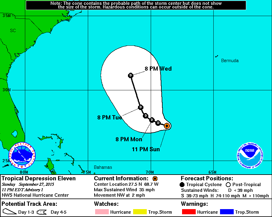
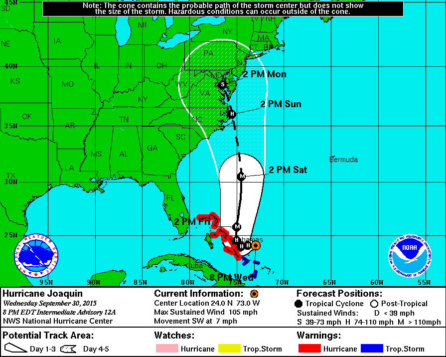
How big of a pain the arse has Joaquin been for the NHC up to this point?
Notice the 8 pm Wednesday position in the first advisory vs. this evenings advisory


Notice the 8 pm Wednesday position in the first advisory vs. this evenings advisory


Posted on 9/30/15 at 9:34 pm to rds dc
Just moved to Winston-Salem, NC earlier this month...looks like we will be on the outer edge of this its track Sunday. May have to head to the mountains.
Posted on 9/30/15 at 9:35 pm to rds dc
quote:
rds dc
I'm really enjoying your posts, thanks for sharing.
Looking at the satellite loops, I bet the morning news is a going to be about the panic on the east coast. Looks like it has the dry air blocked out to its north and east. Has plenty of fuel. Wouldn't want to be in the Bahamas right now. I'm thinking we have a Cat 5 by morning.
Posted on 9/30/15 at 9:41 pm to TheWhizzinator
quote:
May have to head to the mountains.
I'd head to Asheville for a couple of weeks and live at the HempHead commune.
Posted on 9/30/15 at 9:50 pm to rds dc
Joaquin looks nasty today. Hope it weakens before landfall.
Posted on 9/30/15 at 9:56 pm to aVatiger
Good thing Baltimore has a professional crisis manager in Stephanie Blake. 
Posted on 9/30/15 at 10:01 pm to TheWhizzinator
Lived in that area a couple years whizz, and have family there. Hope it turns away for you.
Popular
Back to top


 0
0


