- My Forums
- Tiger Rant
- LSU Recruiting
- SEC Rant
- Saints Talk
- Pelicans Talk
- More Sports Board
- Fantasy Sports
- Golf Board
- Soccer Board
- O-T Lounge
- Tech Board
- Home/Garden Board
- Outdoor Board
- Health/Fitness Board
- Movie/TV Board
- Book Board
- Music Board
- Political Talk
- Money Talk
- Fark Board
- Gaming Board
- Travel Board
- Food/Drink Board
- Ticket Exchange
- TD Help Board
Customize My Forums- View All Forums
- Show Left Links
- Topic Sort Options
- Trending Topics
- Recent Topics
- Active Topics
Started By
Message
Hurricane Season - August - Potential Tropical Cyclone #9
Posted on 8/1/17 at 6:39 pm
Posted on 8/1/17 at 6:39 pm

PTC9

Gert

This post was edited on 8/17/17 at 10:26 am
 28
28

Posted on 8/1/17 at 6:40 pm to rds dc
Good, leaving on a cruise out of NOLA in less than two weeks. It would suck to have a storm in the gulf.
Posted on 8/1/17 at 6:40 pm to rds dc
Thanks, a major Storm is now on the way, Jinks!
Posted on 8/1/17 at 6:41 pm to rds dc
Thanks for the good news, let us hope it stays this way.
Posted on 8/1/17 at 6:42 pm to rds dc
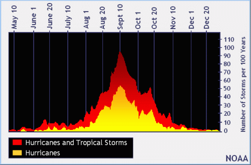
The season so far is above avg for names but below avg for ACE but that doesn't mean much. Almost all major hurricanes form after Aug 1 when climo suggest that conditions become more favorable for development. The SAL (dusty air coming off of Africa) starts to die down and shear starts to relax across the basin and that combo is less hostile towards storms forming.
Posted on 8/1/17 at 6:45 pm to Friscodog
quote:
Good, leaving on a cruise out of NOLA in less than two weeks. It would suck to have a storm in the gulf.
A lot can change in two weeks
The models do show an unusual pattern that keeps driving "cold" fronts into the Gulf. That is always a source for potential trouble and we just saw Emily pop off of one.

Posted on 8/1/17 at 6:47 pm to Friscodog
quote:
Good, leaving on a cruise out of NOLA in less than two weeks. It would suck to have a storm in the gulf.
Punta Cana?
Posted on 8/1/17 at 6:48 pm to rds dc
quote:
The models do show an unusual pattern that keeps driving "cold" fronts into the Gulf.
That is a lot of blue for early August

Posted on 8/1/17 at 6:59 pm to rds dc
Let's hope we aren't revisiting this post like an old Trump tweet.
Posted on 8/1/17 at 7:28 pm to rds dc
I thought cold fronts would be a good thing. Don't we want to keep the gulf temps down as much as possible?
Posted on 8/1/17 at 7:40 pm to Lethrill
quote:
I thought cold fronts would be a good thing. Don't we want to keep the gulf temps down as much as possible?
The Gulf is plenty warm right now and the fronts aren't clearing the Gulf. They are more just kind of sagging into the Gulf and leaving a potential focus for development. However, systems that form that way are often weak and sheared.
Posted on 8/1/17 at 8:15 pm to rds dc
Above avg for names because they jump the gun and name something that lasts less than 24hrs or is a fish. Gotta get their predictions right.
Posted on 8/1/17 at 8:25 pm to GCTigahs
Jay Grimes just posted there is a 10% chance of development with a system in the gulf
Posted on 8/3/17 at 9:33 am to rds dc
NHC is going with 60% for 99L but it is still way out by Africa.

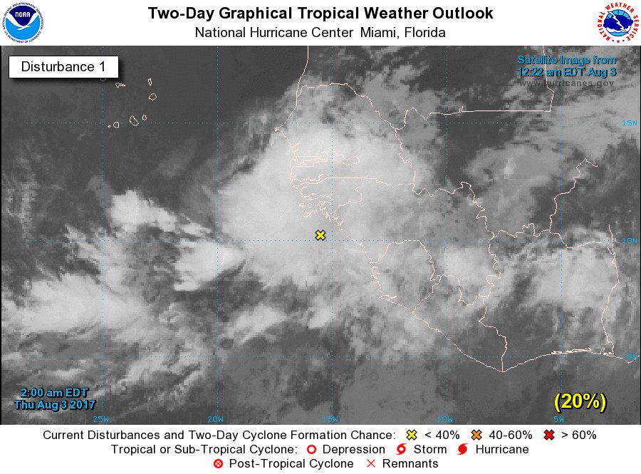
Tropical Weather Outlook
NWS National Hurricane Center Miami FL
800 AM EDT Thu Aug 3 2017
For the North Atlantic...Caribbean Sea and the Gulf of Mexico:
1. A large area of showers and thunderstorms centered about 500 miles
southeast of the Cabo Verde Islands is associated with a vigorous
tropical wave. Environmental conditions are forecast to be conducive
for gradual development, and a tropical depression could form by
early next week over the eastern or central tropical Atlantic
Ocean. This system is forecast to move toward the west or
west-northwest at 10 to 15 mph for the next several days.
* Formation chance through 48 hours...low...30 percent.
* Formation chance through 5 days...medium...60 percent.
Forecaster Stewart
Of more interest is the potential for a system to spin up in the Gulf middle of next week (this would be unrelated to 99L).
Above image via @MJVentrice

Posted on 8/3/17 at 9:43 am to rds dc
It seems likely ke we had a little storm around this parts around this time last year
Posted on 8/3/17 at 9:58 am to theunknownknight
I'm gonna throw a curve ball into the typical OT response.
I'll be in the keys next week, will this screw my trip up?
I'll be in the keys next week, will this screw my trip up?
Posted on 8/3/17 at 10:54 am to rds dc
Thursday, August 03, 2017
INVEST 99L. 12Z (7 am CDT )
10.0 N 19.0 W MOVG W at 10 KT
Pressure: 1010 millibars (29.83 in hg).
Max winds : 25 KT ( convection)
INVEST 99L. 12Z (7 am CDT )
10.0 N 19.0 W MOVG W at 10 KT
Pressure: 1010 millibars (29.83 in hg).
Max winds : 25 KT ( convection)
Posted on 8/3/17 at 2:07 pm to rds dc
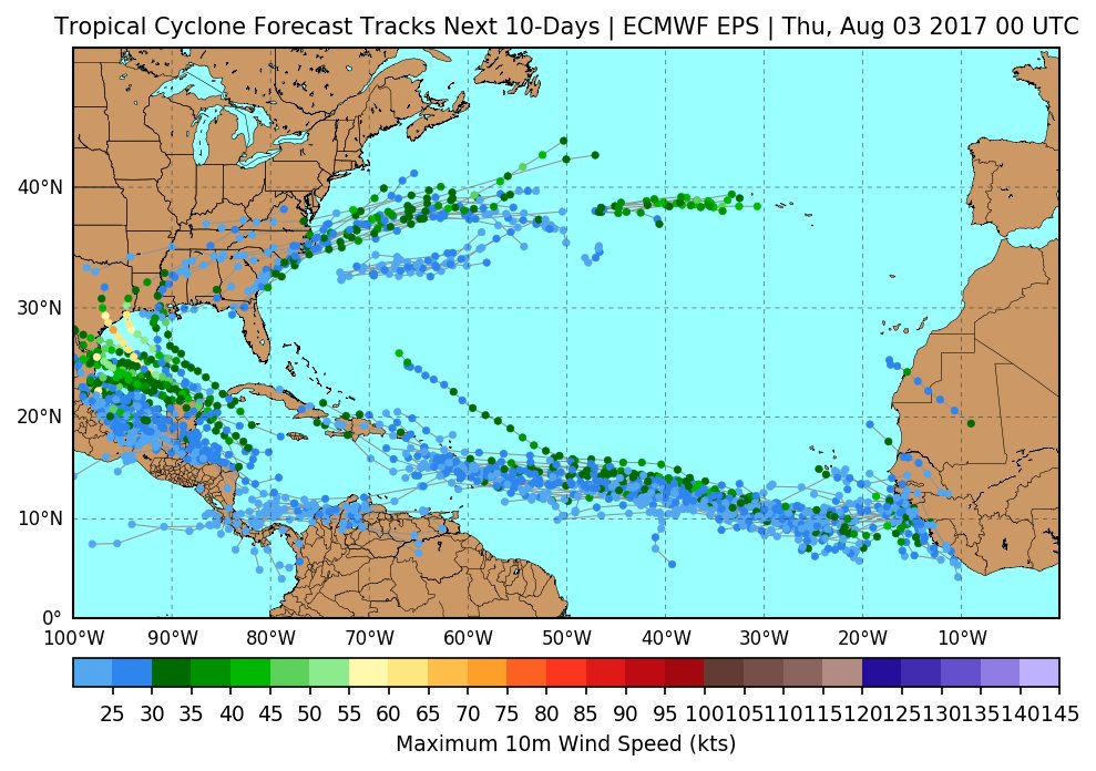
90L is on the board now, this is a potential Gulf threat (yellow shaded area)

Posted on 8/3/17 at 2:54 pm to rds dc
Gonna be interesting watching the storm out by Africa.
Whats the timeline on it getting to our side of the globe if it makes it that far?
Whats the timeline on it getting to our side of the globe if it makes it that far?
Posted on 8/3/17 at 2:55 pm to bharris4qb1
quote:
Gonna be interesting watching the storm out by Africa.
Probably going out to sea

 Page 1 of 8

Popular
Back to top