- My Forums
- Tiger Rant
- LSU Recruiting
- SEC Rant
- Saints Talk
- Pelicans Talk
- More Sports Board
- Fantasy Sports
- Golf Board
- Soccer Board
- O-T Lounge
- Tech Board
- Home/Garden Board
- Outdoor Board
- Health/Fitness Board
- Movie/TV Board
- Book Board
- Music Board
- Political Talk
- Money Talk
- Fark Board
- Gaming Board
- Travel Board
- Food/Drink Board
- Ticket Exchange
- TD Help Board
Customize My Forums- View All Forums
- Show Left Links
- Topic Sort Options
- Trending Topics
- Recent Topics
- Active Topics
Started By
Message
re: Central & Southern U.S. Severe Weather Continues: 4/27/2024 - 4/29/2024
Posted on 4/27/24 at 11:20 pm to Bobby OG Johnson
Posted on 4/27/24 at 11:20 pm to Bobby OG Johnson
Severe Weather Situation Update - April 27, 2024
SEVERE WEATHER IMPACTS STATE
April 27, 2024 – 11 p.m. Update
The State Emergency Operations Center remains activated due to ongoing severe weather. The Oklahoma Department of Emergency Management (OEM) remains in contact with emergency managers across the state and is coordinating with agencies and organizations including the Oklahoma Highway Patrol, Oklahoma Corporation Commission, Oklahoma State Department of Health, Oklahoma National Guard, Oklahoma Department of Transportation, Oklahoma Office of Homeland Security, Oklahoma Department of Agriculture, Food and Forestry, Oklahoma Insurance Department, Oklahoma Department of Environmental Quality, National Weather Service, Oklahoma American Red Cross, the Salvation Army, and the Oklahoma Voluntary Organizations Active in Disaster.
STORM REPORTS
Damage assessments are ongoing in numerous areas and won’t be complete until storms have passed through the impacted areas, however the following damages have been reported to the State Emergency Operations Center as of 11 p.m.
Oklahoma Highway Patrol (OHP) reports injuries and power lines down in Carter County at the Flying J trick stop on Michelin Road. OHP reports additional injuries in Sulphur.
Cotton County Emergency Management reports three to five homes damaged in the Devol area. Numerous trees are down. One storm-related vehicle accident is also reported.
Duncan Emergency Management reports roadway flooding in the City of Duncan.
Stephens County Emergency Management reports Clarity Creek in Duncan is close to overflowing. US 81 is closed near Elder Ave. due to flooding.
Garfield County Emergency Management reports two homes damaged in the Hillsdale area.
Grant County Emergency Management reports numerous trees damaged or down.
Kay County Emergency Management reports three to four structures were damaged by storms earlier this evening northwest of Newkirk. Numerous trees and power poles were down. Two vehicle accidents were a result of the storms. Heavy rain also caused flooding on area roads.
Lincoln County Emergency Management reports debris and damage in the Davenport and Sparks areas.
Marlow Emergency Management reports roadway flooding on Highway 81 and E. Apache Ave.
McClain County Emergency Management reports damage west of Goldsby along Highway 74B.
Midwest City Emergency Management reports at least one structure damaged and multiple powerlines and limbs down.
Payne County Emergency Management reports damage to trees and outbuildings near Lone Chimney.
Tillman County Emergency Management reports flash flooding north of Grandfield. Numerous powerlines are down.
POWER OUTAGES
Approximately 11,300 outages are reported statewide. Areas with the highest number of damages are Carter, Stephens, Murray, McClain, Alfalfa, Garvin, Kay, and Cotton counties.
RESIDENTS ASKED TO REPORT DAMAGE
Oklahoma Department of Emergency Management is asking residents impacted by the storms to report damages to their property at damage.ok.gov. Reporting damage helps local and state emergency managers better coordinate response and recovery efforts. Residents can report damage to homes, businesses or agriculture through the online survey.
DIAL 211
For Oklahoma residents seeking non-emergency disaster or health and human service information, please contact your local 2-1-1. Services are available 24 hours a day by dialing 2-1-1 from your home or cellular telephone. Please only call 911 for emergencies.
OK Gov Website LINK
This post was edited on 4/27/24 at 11:23 pm
 0
0


Posted on 4/27/24 at 11:20 pm to Bobby OG Johnson

Posted on 4/27/24 at 11:21 pm to Bobby OG Johnson
It looks to have lifted just before getting into Okemah.
Posted on 4/27/24 at 11:21 pm to Bobby OG Johnson

Posted on 4/27/24 at 11:22 pm to Bobby OG Johnson

Posted on 4/27/24 at 11:29 pm to Bobby OG Johnson
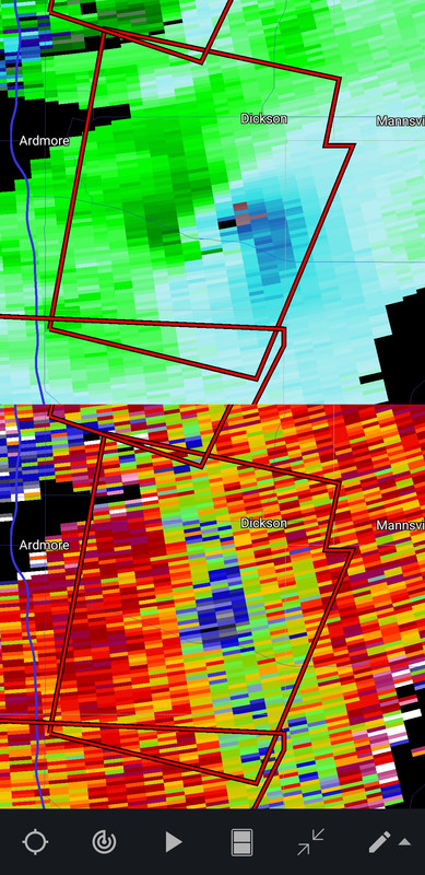
I think the one near Okemah has lifted, which leaves the storm approaching Dickson as the only confirmed tornado right now. It is just barely close enough to a radar to tell it is on the ground.
Posted on 4/27/24 at 11:29 pm to Bobby OG Johnson

Posted on 4/27/24 at 11:30 pm to LegendInMyMind
quote:
which leaves the storm approaching Dickson
Just continued the PDS
Posted on 4/27/24 at 11:31 pm to Bobby OG Johnson
It says something for the environment today/tonight that although none of these storms have really had anything close to a classic look they've still gotten the job done.
Posted on 4/27/24 at 11:32 pm to LegendInMyMind
That tornado heading towards Dickson has one of the biggest debris balls I've seen. Crazy
Posted on 4/27/24 at 11:34 pm to LegendInMyMind
Continued the Ixl PDS

Posted on 4/27/24 at 11:36 pm to Bobby OG Johnson
What is IXL? Is it a town? All caps is throwing me off.
Posted on 4/27/24 at 11:38 pm to LegendInMyMind
quote:
What is IXL? Is it a town? All caps is throwing me off.
You'll have to ask one of the Okies on that one
Posted on 4/27/24 at 11:40 pm to Bobby OG Johnson
frick

Posted on 4/27/24 at 11:42 pm to Bobby OG Johnson

Posted on 4/27/24 at 11:43 pm to LegendInMyMind
I hope Dickson does ok through this. Not much in that little town but there's a gas station on the south side of the highway that used to serve damn good burgers. I haven't been there in a few years but good people between there and Mannsville.
We occasionally go with friends to the ATV off road park there.
We occasionally go with friends to the ATV off road park there.
Posted on 4/27/24 at 11:44 pm to Bobby OG Johnson
They didn't call it a deadly tornado in the warning, which we've seen done before, so hopefully that doesn't mean it has caused a fatality.

Posted on 4/27/24 at 11:45 pm to LegendInMyMind
Glad I’m still awake.
Posted on 4/27/24 at 11:49 pm to El Segundo Guy
The bad news is that they have another one right behind this one that could put one down. It is on the tail end of that line.

 Page 13 of 18

Popular
Back to top