- My Forums
- Tiger Rant
- LSU Recruiting
- SEC Rant
- Saints Talk
- Pelicans Talk
- More Sports Board
- Fantasy Sports
- Golf Board
- Soccer Board
- O-T Lounge
- Tech Board
- Home/Garden Board
- Outdoor Board
- Health/Fitness Board
- Movie/TV Board
- Book Board
- Music Board
- Political Talk
- Money Talk
- Fark Board
- Gaming Board
- Travel Board
- Food/Drink Board
- Ticket Exchange
- TD Help Board
Customize My Forums- View All Forums
- Show Left Links
- Topic Sort Options
- Trending Topics
- Recent Topics
- Active Topics
Started By
Message
re: Another Derecho currently ongoing in Kansas, 90+ winds and large hail
Posted on 5/19/24 at 9:38 pm to Roll Tide Ravens

Posted on 5/19/24 at 9:38 pm to Roll Tide Ravens
 0
0

Posted on 5/19/24 at 9:38 pm to NorthEndZone
Posted on 5/19/24 at 9:38 pm to OU Guy
Modern technology is unbelievable

Posted on 5/19/24 at 9:39 pm to OU Guy
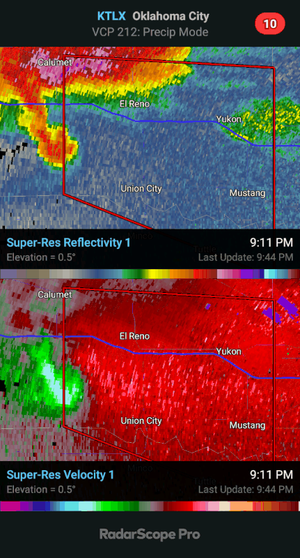
It’s a multiple vortex tornado.
Posted on 5/19/24 at 9:40 pm to SWLA92
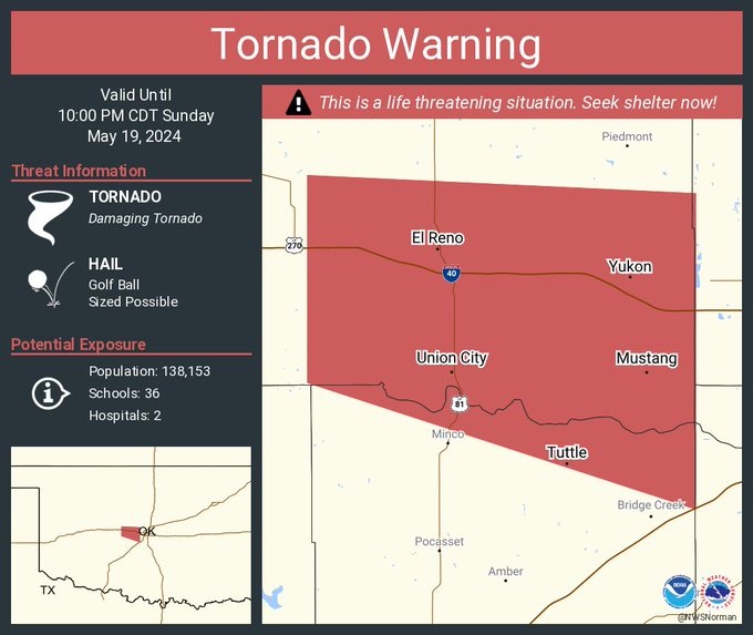
About to head into Settler's Ridge area of OKC south of I-40. Heavily populated.
Reno Avenue
Hope they are taking cover
Reno Avenue
Hope they are taking cover
Posted on 5/19/24 at 9:41 pm to Roll Tide Ravens
TDS on radar.

Posted on 5/19/24 at 9:41 pm to NorthEndZone
Multiple vortices not good 114 mph winds
This post was edited on 5/19/24 at 9:42 pm
Posted on 5/19/24 at 9:42 pm to NorthEndZone
Posted on 5/19/24 at 9:42 pm to SWLA92
4 miles SW of Yukon OK hading into heavily populated areas
Posted on 5/19/24 at 9:43 pm to Roll Tide Ravens

Posted on 5/19/24 at 9:44 pm to Bobby OG Johnson
Posted on 5/19/24 at 9:45 pm to OU Guy
Posted on 5/19/24 at 9:47 pm to OU Guy
Classic stovetop tornado
Posted on 5/19/24 at 9:47 pm to NorthEndZone
That's one hell of an occlusion.
Posted on 5/19/24 at 9:50 pm to LegendInMyMind
The original tornado started to occlude and has just shrank down to a pinpoint. New rotation took over.
Posted on 5/19/24 at 9:51 pm to LegendInMyMind
Posted on 5/19/24 at 9:58 pm to LegendInMyMind
My sirens are going off again. Hail is picking up. Raining like a mofu. Lighting galore
Posted on 5/19/24 at 9:59 pm to LegendInMyMind
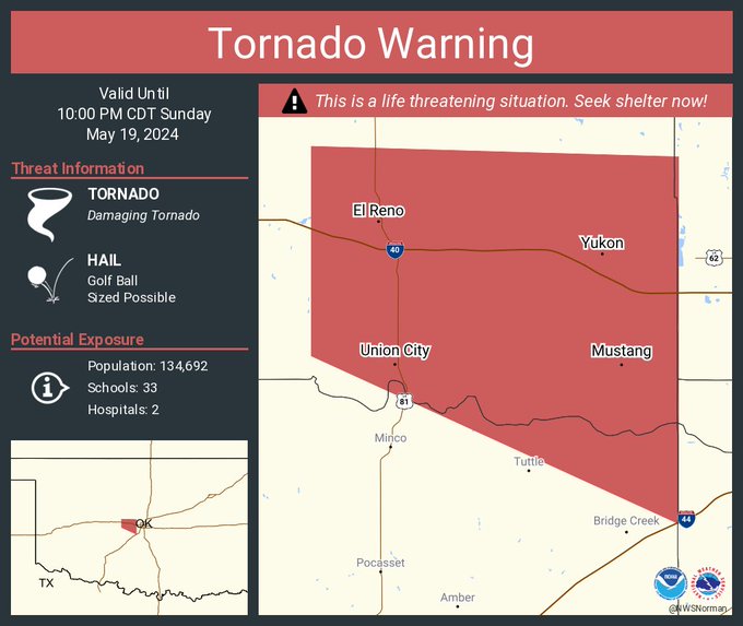
Warning for OKC near Mustang - only radar indicated at the moment
quote:
BULLETIN - EAS ACTIVATION REQUESTED
Tornado Warning
National Weather Service Norman OK
956 PM CDT Sun May 19 2024
The National Weather Service in Norman has issued a
* Tornado Warning for...
Southwestern Oklahoma County in central Oklahoma...
Northwestern Cleveland County in central Oklahoma...
Southeastern Canadian County in central Oklahoma...
Northwestern McClain County in central Oklahoma...
* Until 1045 PM CDT.
* At 955 PM CDT, a severe thunderstorm capable of producing a tornado
was located over southwestern Oklahoma City, or near Mustang,
moving east at 25 mph. This storm has a history of producing
tornadoes!
HAZARD...Tornado and golf ball size hail.
SOURCE...Radar indicated rotation.
IMPACT...Flying debris will be dangerous to those caught without
shelter. Mobile homes will be damaged or destroyed.
Damage to roofs, windows, and vehicles will occur. Tree
damage is likely.
* Locations impacted include...
Oklahoma City, western Norman, Moore, Midwest City, Del City,
Newcastle, Yukon, Bethany, Mustang, Warr Acres, Tuttle, Valley
Brook, Tinker Air Force Base, Forest Park, Woodlawn Park, Lake
Aluma, and Smith Village.
This includes the following highways...
Interstate 35 between mile markers 110 and 133.
Interstate 40 between mile markers 132 and 157.
Interstate 44 between mile markers 107 and 128.
Interstate 240 between mile markers 1 and 9.
This post was edited on 5/19/24 at 10:00 pm
Posted on 5/19/24 at 10:06 pm to NorthEndZone
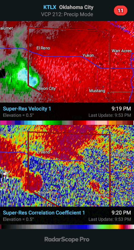
Tornado or not, this is a healthy supercell storm.


 Page 8 of 10

Back to top