- My Forums
- Tiger Rant
- LSU Recruiting
- SEC Rant
- Saints Talk
- Pelicans Talk
- More Sports Board
- Fantasy Sports
- Golf Board
- Soccer Board
- O-T Lounge
- Tech Board
- Home/Garden Board
- Outdoor Board
- Health/Fitness Board
- Movie/TV Board
- Book Board
- Music Board
- Political Talk
- Money Talk
- Fark Board
- Gaming Board
- Travel Board
- Food/Drink Board
- Ticket Exchange
- TD Help Board
Customize My Forums- View All Forums
- Show Left Links
- Topic Sort Options
- Trending Topics
- Recent Topics
- Active Topics
Started By
Message
re: I-10 Severe Weather/Flooding Threat Rd. 2- Thursday/Friday
Posted on 5/16/24 at 11:00 pm to LegendInMyMind

Posted on 5/16/24 at 11:00 pm to LegendInMyMind
The first polygon was amateur hour but the confirmed warning corrected it.
 2
2


Posted on 5/16/24 at 11:00 pm to theunknownknight
quote:
South LP better buckle up too - there is a nice solid rotation headed straight for it
Is Springfield in the path?
Posted on 5/16/24 at 11:00 pm to slackster
Tornado to the north and dust/light debris being kicking up by the bowing segment to the south.
ETA: Not all of that is debris. You can see the CC drop on the bowing segment when the radar is in motion.
ETA: Not all of that is debris. You can see the CC drop on the bowing segment when the radar is in motion.
This post was edited on 5/16/24 at 11:02 pm
Posted on 5/16/24 at 11:01 pm to The Boat
quote:
The first polygon was amateur hour but the confirmed warning corrected it.
Yeah the storm stayed in it for about 20% of the polygon length.
This post was edited on 5/16/24 at 11:02 pm

Posted on 5/16/24 at 11:01 pm to sportsaddit68
Still kicking arse in north Walker…. Wind is crazy.
Posted on 5/16/24 at 11:01 pm to The Boat
Gramercy under the gun also.
Posted on 5/16/24 at 11:01 pm to LegendInMyMind
Convent checking in. Wife and kids in a closet and I’m in the hallway.
Heard some noise but I can’t really confirm anything else right now.
Heard some noise but I can’t really confirm anything else right now.

Posted on 5/16/24 at 11:01 pm to NorthEndZone
yep and gonna worse worse after midnight
Posted on 5/16/24 at 11:02 pm to upgrade
Guys at my plant in convent said it’s absolutely crazy. Probably formed right over them

Posted on 5/16/24 at 11:02 pm to Tiger328

Posted on 5/16/24 at 11:02 pm to slackster
quote:
Yeah the storm stayed in it for about 20% of the polygon length
That rapid intensification of the bowing segment/gust front picked the tors speed up considerably.
Posted on 5/16/24 at 11:02 pm to NorthEndZone
Paincourtville to Convent area seems to get a surprising amount of tornados relative to the surrounding areas.

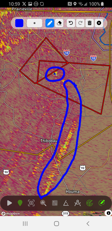
Posted on 5/16/24 at 11:02 pm to theunknownknight
What’s that
Posted on 5/16/24 at 11:03 pm to upgrade
Good luck baw
Posted on 5/16/24 at 11:03 pm to TDsngumbo
Indication of rotation or possibility
Posted on 5/16/24 at 11:04 pm to TDsngumbo
quote:
What’s that
Nothing. Just a return artifact.
Posted on 5/16/24 at 11:04 pm to Tiger328
quote:
Guys at my plant in convent said it’s absolutely crazy. Probably formed right over them
Impala?

Posted on 5/16/24 at 11:04 pm to LegendInMyMind
Thanks again to you, boat, and all of our other weather people for always giving us needed info 
Posted on 5/16/24 at 11:05 pm to Teddy1388
Could have another form on the backside of the first.
Posted on 5/16/24 at 11:05 pm to upgrade
This storm is unfortunately tracking along the river which is where the population/industry is also located.

 Page 12 of 19

Popular
Back to top